Drone Real Estate Photo Editing Guide: Lot Boundary Lines, Landmark Callouts & Twilight Skies (2026)
High-converting drone real estate photo editing turns raw, high-contrast aerial DNG brackets into clear location marketing assets with crisp property boundary lines, landmark pin callouts, and natural sky replacements. Whether your studio flies a DJI Mavic 3 Pro, Air 3, or Mini 4 Pro across suburban subdivisions, coastal estates, or commercial developments, Photo Services Vietnam (PSVN) processes your aerial brackets overnight within 12 hours—starting at $0.60 USD (A$0.90 AUD · £0.50 GBP) for single aerial exposures and $0.75–$0.85 USD (A$1.15–A$1.30 AUD · £0.65–£0.70 GBP) for multi-bracket aerial HDR blending via our professional real estate photo editing service.
By Khanh Tran & PSVN Aerial Post-Production QC Team · Updated October 24, 2026
Drone Real Estate Photo Editing Rate Card & Add-On Pricing (USD, AUD & GBP)
Aerial frames require specialized color grading because small drone sensors suffer from atmospheric haze, cyan roof casts, and harsh midday shadow contrast. Below is our transparent 2026 studio pricing breakdown aligned with our Real Estate Photo Editing Pricing Guide:
| Aerial Editing Deliverable | PSVN Studio Cost (USD) | PSVN Studio Cost (AUD / GBP) | Typical Studio Retail Charge | Turnaround SLA |
|---|---|---|---|---|
| Single Exposure Aerial Polish (Sky, haze, grass, verticals) | $0.60 USD / photo | A$0.90 AUD · £0.50 GBP | $15 – $25 / photo (or $150+ aerial add-on) | 12 hours overnight |
| 3- or 5-Bracket AEB Aerial HDR Blend | $0.75 – $0.85 USD / photo | A$1.15–A$1.30 AUD · £0.65–£0.70 GBP | $20 – $35 / photo | 12 hours overnight |
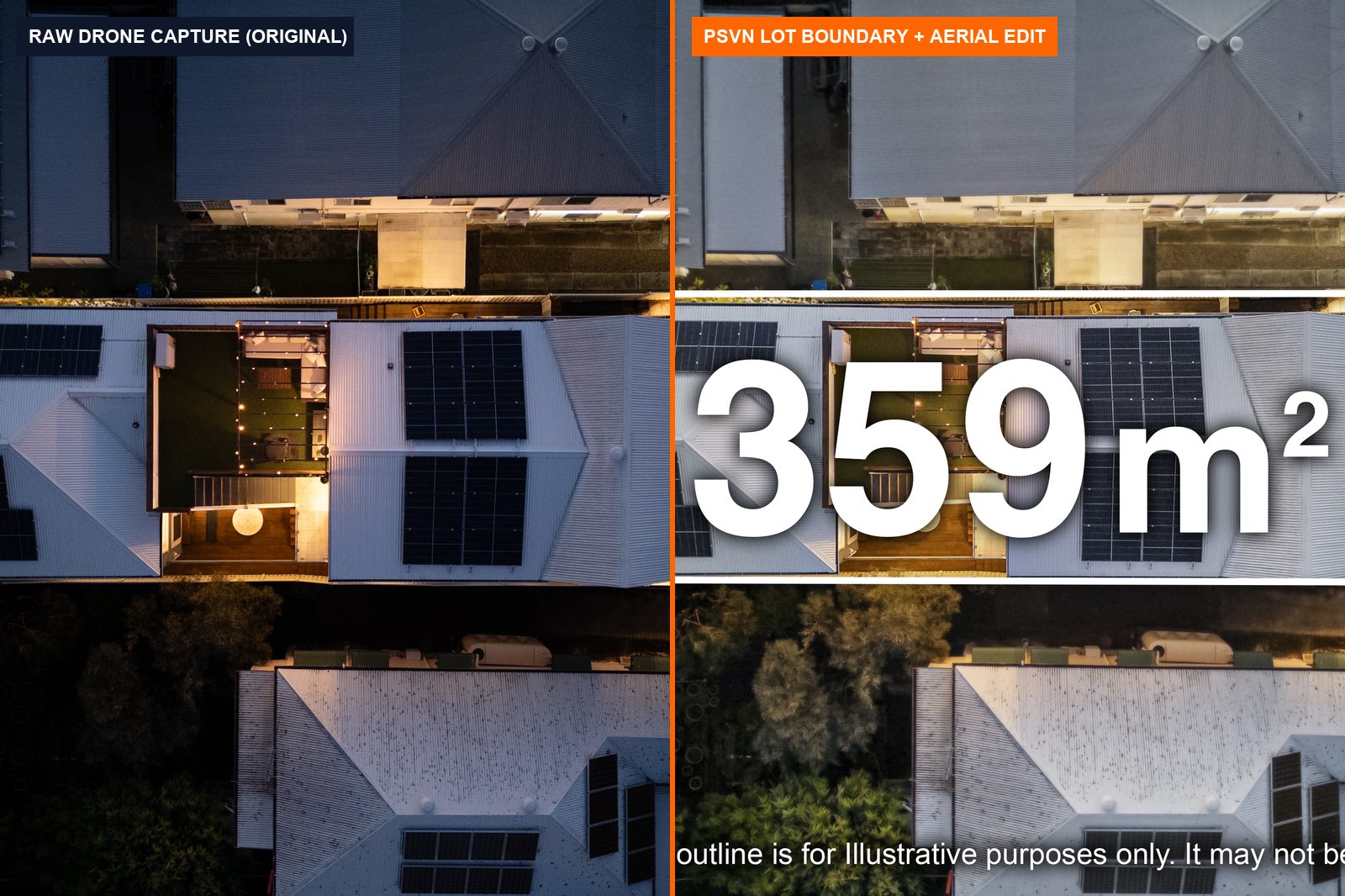
Lot Boundary Outline + Area Overlay (m² / acres / sq ft) | Included or $1.50 – $3.00 USD (complex multi-lot polygons) | A$2.30–A$4.50 AUD · £1.25–£2.50 GBP | $35 – $75 / graphic | 12 hours overnight |
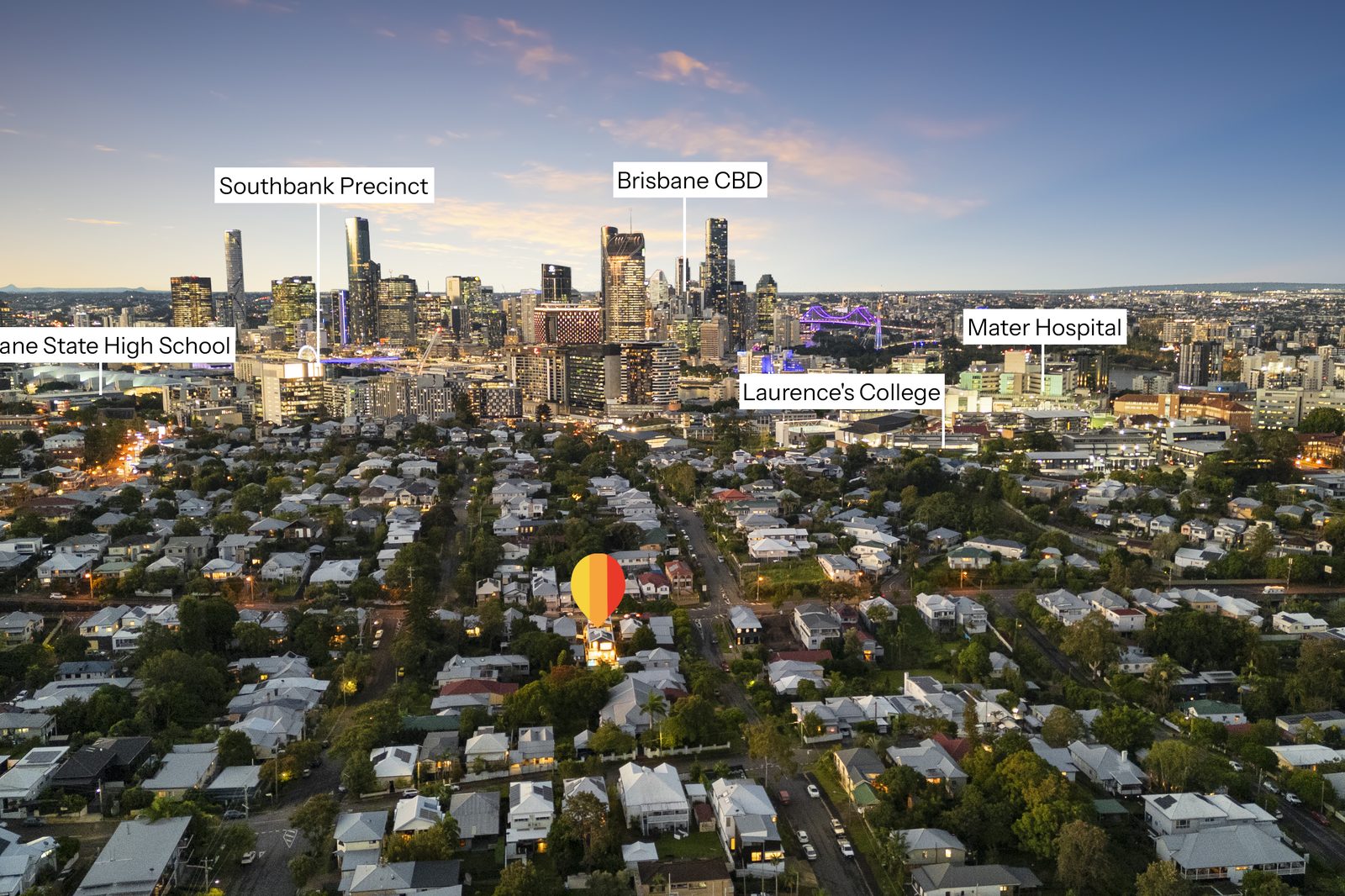
| Location Landmark Pin Callouts (CBD, schools, transit, beach) | $1.50 – $5.00 USD / photo | A$2.30–A$7.50 AUD · £1.25–£4.00 GBP | $45 – $95 / graphic | 12 hours overnight |
| Aerial Day-to-Dusk Virtual Twilight | $3.50 – $4.00 USD / photo | A$5.50–A$6.00 AUD · £3.00–£3.50 GBP | $50 – $90 / hero shot | 12–24 hours overnight |
| Aerial Clutter Cleanup (Vehicles, bins, neighbor roofs) | $1.50 – $5.00 USD / photo | A$2.30–A$7.50 AUD · £1.25–£4.00 GBP | $25 – $50 / photo | 12–24 hours overnight |
5 Core Techniques in Studio-Grade Aerial & Drone Post-Production
Unlike eye-level exterior shots, drone photographs capture wide horizon lines, neighboring properties, and complex roof geometries. Every aerial upload processed by PSVN goes through five dedicated editing steps before passing our 2-Layer Quality Control inspection:
- Atmospheric Dehazing & Horizon Color Correction: High-altitude shots looking toward city skylines or coastlines often look washed out in pale blue haze. Our editors apply targeted local contrast curves and graduated horizon masks so distant landmarks (like the Brisbane CBD, Sydney Harbour, or downtown Austin) remain crisp without darkening the foreground roof.
- Wide-Angle Barrel Distortion & Horizon Leveling: Drone 24mm-equivalent lenses introduce subtle horizon curvature when the gimbal is pitched between
-15°and-35°. We apply custom DJI lens profiles and true vertical alignment so high-rise towers and boundary fences stand 100% plumb. - Precision Lot Boundary Lines & Semi-Transparent Fills: When marketing acreage, corner lots, or infill development parcels, buyers need to know exactly where the property starts and ends. Send us a screenshot from Google Maps, Nearmap, RP Data/CoreLogic, or the county plat map—our graphic editors draw clean white, orange (
#FF6600), or brokerage-branded vector outlines with optional shaded overlays and area labels (359m²,1.25 Acres). - Landmark Pin Drops & Distance Callouts: Especially popular across Australian REA/Domain campaigns and US commercial listings, we add modern drop-pins highlighting key lifestyle amenities (“Brisbane CBD – 4.2km”, “Mater Hospital”, “Southbank Precinct”).
- Roof, Driveway & Neighbor Yard Decluttering: An aerial view reveals everything—parked cars in the driveway, solar panel dust, brown lawn patches, and construction debris next door. We combine natural turf repair with targeted digital item removal while keeping material representations 100% compliant with MLS and consumer protection laws.
How to Shoot Drone Brackets for Flawless Overnight Editing
To get the cleanest results from our overnight editing pods, configure your drone camera settings using this field checklist:
- Shoot 3- or 5-Bracket AEB in DNG RAW (
±0.7 EVor±1.0 EV): Drone CMOS sensors have narrower dynamic range than full-frame Sony or Canon bodies. Shooting a 3-bracket Auto Exposure Bracketing (AEB) burst preserves both bright cloud highlights and shaded patio details. - Capture 3 Mandatory Angles per Property:
1. Low-Oblique Front Hero (12m–20maltitude): Replaces a tall mast shot, clearing street trees while keeping the front facade recognizable.
2. High-Oblique Context Shot (45m–80maltitude): Shows the property in relation to the coastline, golf course, or city skyline (ideal for pin callouts).
3. Top-Down Nadir /75°Lot Overview: Shows the full backyard, pool, alfresco area, and fence lines (ideal for lot boundary outlines). - Include 10-Bit D-Log M / HLG Video Clips: If you capture 15-second orbital and reveal drone clips during the same flight, our video team seamlessly color-grades and speed-ramps them inside your overnight real estate walkthrough video and 9:16 vertical reel.
Frequently Asked Questions
How do I tell PSVN where to draw the lot boundary lines on my drone photos?
Simply include a screenshot from Google Maps, RP Data, LandGlide, or the tax parcel map in your upload folder—or draw a rough line on your iPad/phone. Our editors trace the exact fence lines and architectural markers in perspective and include any required brokerage disclaimer text at the bottom of the frame.
Can PSVN convert daytime drone photos into aerial twilight hero shots?
Yes. Our Day-to-Dusk virtual twilight team converts daytime aerial photos into glowing sunset hero shots for $3.50–$4.00 USD (A$5.50–A$6.00 AUD · £3.00–£3.50 GBP)—replacing the sky, illuminating pool water and landscape path lights, and warming every interior window visible from the air.
Are lot boundary overlays and pin callouts allowed on US MLS, UK Rightmove, and Australian REA/Domain?
Australian portals (realestate.com.au and Domain) and UK commercial portals strongly encourage boundary outlines and amenity pins when accompanied by an “Indicative boundary only” disclaimer. For strict North American MLS boards that prohibit text overlays on the primary photo, we deliver both a clean, unlabelled aerial edit for MLS compliance and a branded callout version for social media, Zillow Showcase, and print brochures.
How can I test PSVN’s drone real estate photo editing on my own aerial brackets?
You can start your 100% Free Trial with PSVN today—upload 3 RAW photo sets (including aerial brackets) + 1 video clip at zero cost, receive overnight delivery in 12–24 hours, and get 10% off your first month’s invoice.
Related Articles



Comment